Multi-GNSS UAV Countermeasure & Simulation System Module
Spoofing Defined:
A cyberattack where false GPS/GNSS signals are transmitted to a
receiver.
Unlike jamming, which entirely blocks or disrupts GPS/GNSS signals,
spoofing alters the signals to deceive a receiver into accepting
incorrect data. This manipulation can lead to the display of false
information regarding aircraft position, speed, or time,
potentially causing dangerous outcomes in applications that rely on
accurate GPS/GNSS data.
1. Product Overview
The Navigation Signal Source Module is a satellite navigation
signal simulation module developed using satellite signal
simulation technology. Operating across the operational frequency
bands of GPS, GLONASS, BDS and Galileo navigation systems, it
generates real-time simulated signals that perfectly replicate
actual satellite signals. This enables applications such as drone
navigation spoofing and satellite signal simulation testing,
delivering precise navigation deception capabilities for precision
targeting operations.
This module transmits deceptive navigation satellite signals
designed to mislead drones positioning, navigation, and timing
receivers through location spoofing, speed spoofing, and time
spoofing. When drones receive these deceptive signals, they will
use them to perform positioning maneuvers, enabling multiple
deception methods including directional evasion, hovering, rapid
crash, controlled landing, and flight prohibition.
The module can be customized according to user needs, and is
suitable for petroleum and petrochemical industry, electric power,
public security and other fields.
2. Main Functions
- Be effective to all UAV that relies on navigation satellite
positioning system for positioning, the UAVs can be spoofed so as
to realize functions such as driving away, heading induction,
circular motion, forced landing, flight ban and crash, and can
achieve fixed-point forced landing with the assistance of accurate
detection equipment;
- Support for global navigation satellite signal system and frequency
point simulation, including: BDS, GPS, GLONASS, Galileo, QZSS,
IRNSS;
- It has the function of coordinate simulation, which can simulate
any coordinates on the ground, and also supports generation of
static and dynamic trajectory of points.
- It has the function of receiving navigation satellite signals and
time delay compensation, realizes time synchronization with
in-orbit satellites, and can adjust channel delay according to the
distance to achieve optimal effect, and automatically shield the
same frequency interference;
- It has the functions of ephemeris downloading, parsing and storage,
update and calculation,etc., so that it can obtain ephemeris in the
scene where the satellite signal cannot be received to complete
signal simulation as well;
- It can output high precision 10MHz clock signal;
- It has B code/1PPS signal interface, which can grant time to
external devices through 1PPS+TOD;
- It has the function of device self-test and abnormal case automatic
reporting;
- Provide standard interfaces and protocols to support user
development and integration;
- Support customized development of navigation satellite frequency
points and functions.
3. Technical Specifications
GNSS Signal Output Frequencies
| No | Satellite System | Band | Center Frequency (MHz) | Channel BW (MHz) |
|---|
| 1 | BDS | B1I | 1561.098 | 4.092 |
| 2 | BDS | B2I | 1207.14 | 4.092 |
| 3 | BDS | B2 a | 1176.45 | 20.46 |
| 4 | BDS | B3I | 1268.52 | 20.46 |
| 5 | BDS | B1C | 1575.42 | 32.736 |
| 6 | GPS | L1C/A | 1575.42 | 2.046 |
| 7 | GPS | L2C/A | 1227.6 | 2.046 |
| 8 | GPS | L5 | 1176.45 | 20.46 |
| 9 | GLONASS | G1 | 1602 | 8.3345 |
| 10 | GLONASS | G2 | 1246 | 6.7095 |
| 11 | Galileo | El | 1575.42 | 14.322 |
| 12 | Galileo | E5a | 1176.45 | 20.46 |
| 13 | Galileo | E6 | 1278.75 | 10.23 |
Operational & Performance Parameters
| Parameter | Specification Description |
|---|
| Effective time of spoofing | ≤10s |
| Startup time | ≤10s |
| Cold start available time | ≤60s for perfect working |
| RF Power adjustment range | 0~80dB |
| Output power of signal at each frequency | ≤-5dBm |
| Power resolution | 0.5dB |
| Location simulation accuracy | ≤1m |
| Speed accuracy | ≤0.5m/s (RMS) |
| Time synchronization accuracy | <20ns |
4. Electrical & Environmental Specifications
| Parameter | Specification |
|---|
| Input Voltage | DC 10V ~ 36V |
| Product power consumption | 20W |
| Operating Temperature | –40°C ~ +70°C |
| Storage Temperature | –45°C ~ +85°C |
5. Hardware Interface Definition
| No | Interface Name | Connector Type | Description / Purpose |
|---|
| 1 | E1 signal transmission | SMA Female | Navigation signal output |
| 2 | E2 signal transmission | SMA Female | Navigation signal output |
| 3 | E3 signal transmission | SMA Female | Navigation signal output |
| 4 | E4 signal transmission | SMA Female | Navigation signal output |
| 5 | E5 signal transmission | SMA Female | Navigation signal output |
| 6 | E6 signal transmission | SMA Female | Navigation signal output |
| 7 | E8 signal receiving | SMA Female | Satellite navigation signal receiving port, with 5V power feeding |
| 8 | J2 network interface | RJ45 | Control |
| 9 | J5 board power supply | 3P (DC, GND, PE) | DC 10V~36V |
| 10 | J3 power amplifier switch | 2P (IN, OUT) | DC 10V~36V (The signal is ON when the path is opened, and OFF when
the signal is closed) |
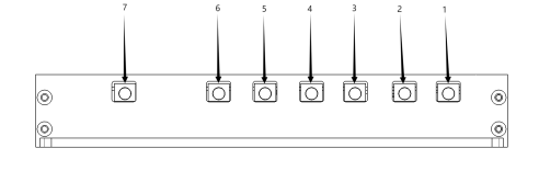

7. Appearance and Dimensions

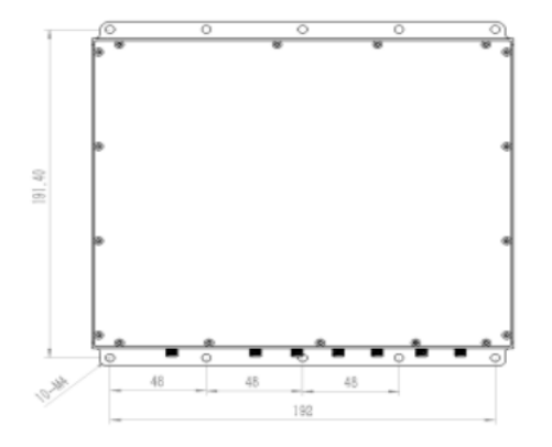
Dimensions (L × W × H): 210 mm × 200.4 mm × 32 mm | Weight: 900 g
8. Standard Package Contents
| No. | Item | Quantity | Specification / Remarks |
|---|
| Hardware |
| 1 | Navigation signal source module | 1 | YBC613 |
| 2 | Accessories | 1 | Power connector, cooling fin |
| 3 | Packing box | 1 |
|
| 4 | RF combiner, 2 to 1 | 1 | PD2S1-0.8-2.7(optional) |
| 5 | RF combiner, 4 to 1 | 1 | PD4S1-0.8-2.7(optional) |
| 6 | Navigation receiving antenna | 1 | RXATN-MASH01(optional) |
| 7 | 1.5G transmitting antenna | 1 | TXATN-BLG-20(optional) |
| 8 | 1.2G transmitting antenna | 1 | TXATN-BLG-1.2G(optional) |
| software |
| 9 | Control software | 1 |
|
| Documentation |
| 10 | User manual | 1 | electronic edition |
| 11 | Application programming protocol | 1 | electronic edition |

 Portable Navigation Signal Source GNSS Spoofing Module Multi Frequency

