| Sign In | Join Free | My infospaceinc.com |
|
| Sign In | Join Free | My infospaceinc.com |
|
| Categories | GNSS Spoofing Module |
|---|---|
| Power Adjustment Range: | 80 dB |
| Model Number: | YBC613 |
| GNSS Synchronization Time: | 150 s |
| Price: | $11,000-$12,000 |
| Packaging Details: | Carton box |
| GNSS Reception Bands: | BDS GPS GPS GLONASS GLONASS Galileo QZSS |
| Brand Name: | Roviyno |
| Supply Ability: | <100 units 30 working days |
| Delivery Time: | 7-10 working days |
| Max Operational Distance: | 1 km (varies by antenna, environment & UAV model) |
| Place of Origin: | China Mainland |
| Operating Temperature: | –30°C ~ +70°C |
| Payment Terms: | T/T |
| Power Consumption (Standby): | ≤ 5 W |
| MOQ: | 1 |
| Company Info. |
| Roviyno Intelligent Technology Co., Limited |
| Verified Supplier |
| View Contact Details |
| Product List |
Roviyno GNSS spoofing modules provide programmable RF signal simulation across multiple satellite navigation systems, offering a compact solution for GNSS receiver testing, navigation development, and OEM integration. GNSS jamming and spoofing are far more common than most people realize. It occurs well beyond conflict zones. Interference is now documented daily across aviation, maritime, land transport, and critical infrastructure operations in Europe, North America, and Asia Pacific, as well as in regions affected by geopolitical tensions.
Global Navigation Satellite System (GNSS) modules are compact electronic components that determine a device’s position, velocity, and time by receiving signals from global navigation systems such as GPS (USA), Galileo (Europe), GLONASS (Russia), QZSS (Japan), BeiDou (China) and NavIC (India).
GNSS modules operate by capturing weak RF (Radio Frequency) signals via an antenna, digitizing them, and using a baseband processor to perform signal acquisition, tracking, and measurement of pseudorange and carrier phase. These measurements are processed by navigation algorithms to compute the position of solution. High-precision GNSS modules achieve centimeter-level accuracy by combining multi-frequency observations with correction data such as RTK.
Regions reporting frequent incidents include:
European airspace: Baltics, Eastern Mediterranean, Black Sea
region, Scandinavia
North America: U.S. aviation corridors, coastal approaches, and
Canadian Arctic routes
Maritime routes: North Sea, Mediterranean, Baltic Sea, East Asia
High density urban zones: London, Paris, New York, Los Angeles,
Toronto
Border areas: Finland, Estonia, Poland, South Korea, Taiwan
Conflict adjacent regions: Eastern Europe, Middle East
Reports from GPSJam.org, IATA, and the OPS Group show thousands of
jamming/spoofing incidents every month, affecting everything from
airliners and cargo ships to drones and survey equipment.
This shows that GNSS jamming and spoofing are not isolated, not
rare, and not limited to zones. They are a global, growing
challenge that impacts everyday operations in peaceful regions
across Europe, the United States, Canada, and beyond.
Highlights:
The Navigation Signal Source Module is a satellite navigation signal simulation module developed using satellite signal simulation technology. Operating across the operational frequency bands of GPS, GLONASS, BDS and Galileo navigation systems, it generates real-time simulated signals that perfectly replicate actual satellite signals. This enables applications such as drone navigation spoofing and satellite signal simulation testing, delivering precise navigation deception capabilities for precision targeting operations.
This module transmits deceptive navigation satellite signals designed to mislead drones positioning, navigation, and timing receivers through location spoofing, speed spoofing, and time spoofing. When drones receive these deceptive signals, they will use them to perform positioning maneuvers, enabling multiple deception methods including directional evasion, hovering, rapid crash, controlled landing, and flight prohibition.
Our GPS/GNSS receiver modules are designed to deliver high-precision positioning within compact, low-power architectures for OEM integration.
Based on multi-frequency GNSS tracking and advanced Real-Time Kinematic (RTK) positioning processing, our GPS/GNSS modules provide reliable, centimeter-level accuracy and high positioning availability in challenging signal environments. GNSS receiver modules integrate multi-frequency, multi-constellation tracking to deliver high-accuracy positioning with minimal power consumption in compact, OEM-ready designs. They retain the reliability and precision performance that receivers are known for.
| No | Satellite System | Band | Center Frequency (MHz) | Channel BW (MHz) |
|---|---|---|---|---|
| 1 | BDS | B1I | 1561.098 | 4.092 |
| 2 | BDS | B2I | 1207.14 | 4.092 |
| 3 | BDS | B2 a | 1176.45 | 20.46 |
| 4 | BDS | B3I | 1268.52 | 20.46 |
| 5 | BDS | B1C | 1575.42 | 32.736 |
| 6 | GPS | L1C/A | 1575.42 | 2.046 |
| 7 | GPS | L2C/A | 1227.6 | 2.046 |
| 8 | GPS | L5 | 1176.45 | 20.46 |
| 9 | GLONASS | G1 | 1602 | 8.3345 |
| 10 | GLONASS | G2 | 1246 | 6.7095 |
| 11 | Galileo | El | 1575.42 | 14.322 |
| 12 | Galileo | E5a | 1176.45 | 20.46 |
| 13 | Galileo | E6 | 1278.75 | 10.23 |
| Parameter | Specification Description |
|---|---|
| Effective time of spoofing | ≤10s |
| Startup time | ≤10s |
| Cold start available time | ≤60s for perfect working |
| RF Power adjustment range | 0~80dB |
| Output power of signal at each frequency | ≤-5dBm |
| Power resolution | 0.5dB |
| Location simulation accuracy | ≤1m |
| Speed accuracy | ≤0.5m/s (RMS) |
| Time synchronization accuracy | <20ns |
| Parameter | Specification |
|---|---|
| Input Voltage | DC 10V ~ 36V |
| Product power consumption | 20W |
| Operating Temperature | –40°C ~ +70°C |
| Storage Temperature | –45°C ~ +85°C |
| No | Interface Name | Connector Type | Description / Purpose |
|---|---|---|---|
| 1 | E1 signal transmission | SMA Female | Navigation signal output |
| 2 | E2 signal transmission | SMA Female | Navigation signal output |
| 3 | E3 signal transmission | SMA Female | Navigation signal output |
| 4 | E4 signal transmission | SMA Female | Navigation signal output |
| 5 | E5 signal transmission | SMA Female | Navigation signal output |
| 6 | E6 signal transmission | SMA Female | Navigation signal output |
| 7 | E8 signal receiving | SMA Female | Satellite navigation signal receiving port, with 5V power feeding |
| 8 | J2 network interface | RJ45 | Control |
| 9 | J5 board power supply | 3P (DC, GND, PE) | DC 10V~36V |
| 10 | J3 power amplifier switch | 2P (IN, OUT) | DC 10V~36V (The signal is ON when the path is opened, and OFF when the signal is closed) |
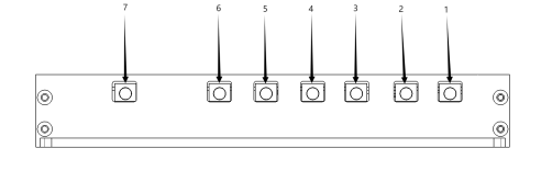


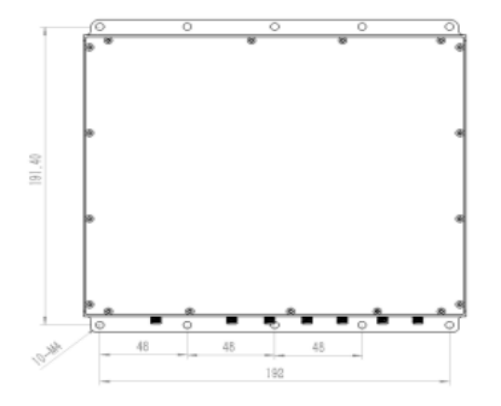
Dimensions (L × W × H): 210 mm × 200.4 mm × 32 mm | Weight: 900 g
| No. | Item | Quantity | Specification / Remarks |
|---|---|---|---|
| Hardware | |||
| 1 | Navigation signal source module | 1 | YBC613 |
| 2 | Accessories | 1 | Power connector, cooling fin |
| 3 | Packing box | 1 | |
| 4 | RF combiner, 2 to 1 | 1 | PD2S1-0.8-2.7(optional) |
| 5 | RF combiner, 4 to 1 | 1 | PD4S1-0.8-2.7(optional) |
| 6 | Navigation receiving antenna | 1 | RXATN-MASH01(optional) |
| 7 | 1.5G transmitting antenna | 1 | TXATN-BLG-20(optional) |
| 8 | 1.2G transmitting antenna | 1 | TXATN-BLG-1.2G(optional) |
| software | |||
| 9 | Control software | 1 | |
| Documentation | |||
| 10 | User manual | 1 | electronic edition |
| 11 | Application programming protocol | 1 | electronic edition |

|

