| Sign In | Join Free | My infospaceinc.com |
|
| Sign In | Join Free | My infospaceinc.com |
|
| Categories | GNSS Spoofing Module |
|---|---|
| Model Number: | YBC613 |
| GNSS Reception Bands: | BDS GPS GPS GLONASS GLONASS Galileo QZSS |
| Price: | $11,000-$12,000 |
| Packaging Details: | Carton box |
| Brand Name: | Roviyno |
| Supply Ability: | <100 units 30 working days |
| Max Operational Distance: | 1 km (varies by antenna, environment & UAV model) |
| Operating Temperature: | –30°C ~ +70°C |
| Payment Terms: | T/T |
| Power Consumption (Standby): | ≤ 5 W |
| Delivery Time: | 7-10 working days |
| Power Adjustment Range: | 80 dB |
| Place of Origin: | China Mainland |
| GNSS Synchronization Time: | 150 s |
| MOQ: | 1 |
| Company Info. |
| Roviyno Intelligent Technology Co., Limited |
| Verified Supplier |
| View Contact Details |
| Product List |
Roviyno GNSS spoofing modules provide programmable RF signal simulation across multiple satellite navigation systems, offering a compact solution for GNSS receiver testing, navigation development, and OEM integration. GPS spoofing technology companies and manufacturers of GNSS drone spoofers for commercial and counter-UAS operations.
GPS drone spoofers are used in counter-UAS (unmanned aerial systems) applications to mitigate unauthorized drone threats. GNSS spoofing technologies operate by over-powering legitimate GNSS satellite signals, such GPS, GLONASS, Galileo and Beidou used by drones to navigate, and replacing them with spurious signals instead. Drone GPS spoofing devices may form part of a complete C-UAS sysytem, which may also include radar-based and electro-optic detection systems, drone capture nets, or hard-kill kinetic effector devices.
Highlights:
The Navigation Signal Source Module is a satellite navigation signal simulation module developed using satellite signal simulation technology. Operating across the operational frequency bands of GPS, GLONASS, BDS and Galileo navigation systems, it generates real-time simulated signals that perfectly replicate actual satellite signals. This enables applications such as drone navigation spoofing and satellite signal simulation testing, delivering precise navigation deception capabilities for precision targeting operations.
GPS drone spoofers emit stronger signals on GNSS frequencies similar to GPS jammers. However, these signals are intended to mimic legitimate positioning and navigation information, thus fooling the drone into thinking that its current location is different to its actual location.
These fake signals can be used to direct the drone away and divert it from its intended trajectory. They can also be used to make the receiver think that the drone is in a geofenced or no-fly area, which may cause the aircraft to immediately stop flying. GNSS drone spoofers may be used to target autonomous drones that are not affected by RF signal jammers since they are not transmitting or receiving signals between themselves and a GCS (ground control station).
| No | Satellite System | Band | Center Frequency (MHz) | Channel BW (MHz) |
|---|---|---|---|---|
| 1 | BDS | B1I | 1561.098 | 4.092 |
| 2 | BDS | B2I | 1207.14 | 4.092 |
| 3 | BDS | B2 a | 1176.45 | 20.46 |
| 4 | BDS | B3I | 1268.52 | 20.46 |
| 5 | BDS | B1C | 1575.42 | 32.736 |
| 6 | GPS | L1C/A | 1575.42 | 2.046 |
| 7 | GPS | L2C/A | 1227.6 | 2.046 |
| 8 | GPS | L5 | 1176.45 | 20.46 |
| 9 | GLONASS | G1 | 1602 | 8.3345 |
| 10 | GLONASS | G2 | 1246 | 6.7095 |
| 11 | Galileo | El | 1575.42 | 14.322 |
| 12 | Galileo | E5a | 1176.45 | 20.46 |
| 13 | Galileo | E6 | 1278.75 | 10.23 |
| Parameter | Specification Description |
|---|---|
| Effective time of spoofing | ≤10s |
| Startup time | ≤10s |
| Cold start available time | ≤60s for perfect working |
| RF Power adjustment range | 0~80dB |
| Output power of signal at each frequency | ≤-5dBm |
| Power resolution | 0.5dB |
| Location simulation accuracy | ≤1m |
| Speed accuracy | ≤0.5m/s (RMS) |
| Time synchronization accuracy | <20ns |
| Parameter | Specification |
|---|---|
| Input Voltage | DC 10V ~ 36V |
| Product power consumption | 20W |
| Operating Temperature | –40°C ~ +70°C |
| Storage Temperature | –45°C ~ +85°C |
| No | Interface Name | Connector Type | Description / Purpose |
|---|---|---|---|
| 1 | E1 signal transmission | SMA Female | Navigation signal output |
| 2 | E2 signal transmission | SMA Female | Navigation signal output |
| 3 | E3 signal transmission | SMA Female | Navigation signal output |
| 4 | E4 signal transmission | SMA Female | Navigation signal output |
| 5 | E5 signal transmission | SMA Female | Navigation signal output |
| 6 | E6 signal transmission | SMA Female | Navigation signal output |
| 7 | E8 signal receiving | SMA Female | Satellite navigation signal receiving port, with 5V power feeding |
| 8 | J2 network interface | RJ45 | Control |
| 9 | J5 board power supply | 3P (DC, GND, PE) | DC 10V~36V |
| 10 | J3 power amplifier switch | 2P (IN, OUT) | DC 10V~36V (The signal is ON when the path is opened, and OFF when the signal is closed) |
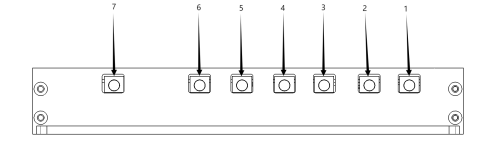


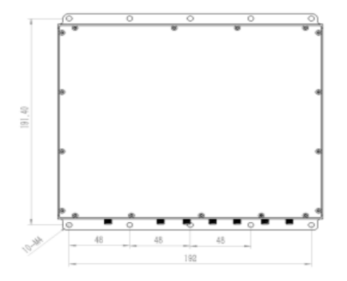
Dimensions (L × W × H): 210 mm × 200.4 mm × 32 mm | Weight: 900 g
| No. | Item | Quantity | Specification / Remarks |
|---|---|---|---|
| Hardware | |||
| 1 | Navigation signal source module | 1 | YBC613 |
| 2 | Accessories | 1 | Power connector, cooling fin |
| 3 | Packing box | 1 | |
| 4 | RF combiner, 2 to 1 | 1 | PD2S1-0.8-2.7(optional) |
| 5 | RF combiner, 4 to 1 | 1 | PD4S1-0.8-2.7(optional) |
| 6 | Navigation receiving antenna | 1 | RXATN-MASH01(optional) |
| 7 | 1.5G transmitting antenna | 1 | TXATN-BLG-20(optional) |
| 8 | 1.2G transmitting antenna | 1 | TXATN-BLG-1.2G(optional) |
| software | |||
| 9 | Control software | 1 | |
| Documentation | |||
| 10 | User manual | 1 | electronic edition |
| 11 | Application programming protocol | 1 | electronic edition |
When selecting a GNSS receiver module, you should consider required positioning accuracy, support for multi‑frequency and multi‑constellation tracking, power consumption, physical size, supported correction services, environmental robustness, and long‑term product availability.
For high-precision applications, look for multi-frequency GNSS modules with support. For embedded systems, consider size, power consumption, and interface compatibility. Reliability in challenging environments, such as urban areas or interference-prone locations, is also critical for consistent performance.
The right balance depends on whether your application prioritizes precision, low power, compact design, or industrial reliability.

|

